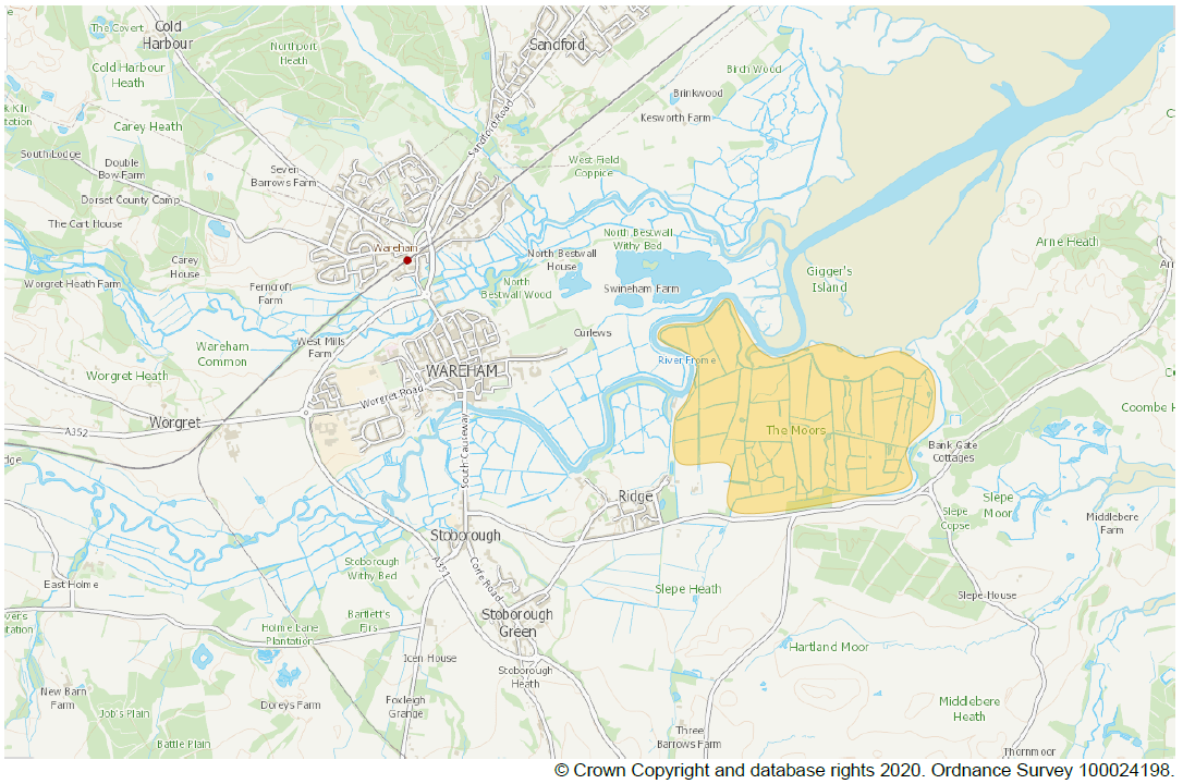
Moors at Arne Coastal Change Project
Introduction
The Environment Agency, RSPB and Natural England are working together to adapt approximately 150 hectares of the Moors at Arne into a diverse wetland habitat.
With sea level rising, important habitat for wildlife all around Poole Harbour be lost over the next 30 years. Where rising waters press against fixed sea defences, ‘coastal squeeze’ occurs, this means a loss of inter-tidal features such as mudflats and salt marsh. New places for coastal wildlife will need to be created to keep the natural features of the lost landscape, and allow the government to realise its 25 year environment plan, whilst flood risk to homes and businesses from the sea continues to be managed.
The project has developed outline proposals since its public launch in October 2018. Thorough surveys and assessments have been conducted that support detailed design and a planning application for summer 2022.
The information on this page has been supplied by the Environment Agency to inform Dorset Coast Forum members and the wider public on the Arne Moors Project. The Dorset Coast Forum is an independent, neutral and non-political Coastal Partnership and will maintain a neutral position, neither for or against the project.
Scan the QR code or visit www.kier.uk/arne to get project news and updates straight into your inbox

Project Overview
In Poole Harbour, the project partners are working together to explore how The Moors at Arne can be converted to inter-tidal habitat to compensate for the ‘coastal squeeze’ losses.
The scheme will involve the construction of new tidal embankments further inland than the existing harbour edge embankments. Once the new embankments are in place, the land in between will be opened to the action of the tides by the creation of three controlled breaches in the existing embankments.
The sediment brought in by the high tides will settle out as the tide turns, and gradually the low lying land will accrete and new mudflats and salt marsh will be created. The tidal water coming through each of the three breaches will have different dynamics and salinity characteristics, and this will lead to a variation of topography and a mosaic of habitats across the site.
The project design also includes shallow saline (salt water) lagoons on the western side to provide feeding grounds and roosting sites for a variety of bird species. These lagoons are important for the long term sustainability of the Special Protection Area (SPA) protected habitat.
In the southerly part of The Moors, there is a Special Area of Conservation (SAC) with internationally rare flora in a unique habitat mix. This area of the site will be protected with an embankment designed to facilitate the best mixture of sustainability and transition in a changing long term climate.
Much of the site is also protected as a wetland of international importance (RAMSAR site) and as a Site of Special Scientific Interest (SSSI). The impact of the project on freshwater features under these protections will be mitigated by the design of new freshwater features in the area to the south of the new embankments. There will also be some compensation off site at land owned by the Environment Agency at East Stoke.

The project is being carefully designed so that there will be no adverse impact on flood risk to any of the neighbouring properties. The flood risk assessment is comprehensive and includes consideration of tidal flood risk, river and stream flood risk, groundwater flood risk and surface water flood risk.
The project is also considering the geomorphological aspects of changes in the River Frome / Poole Harbour (river /tide) interactions. Computer modelling is being used alongside bathymetric surveying, pre- and post-scheme, to predict and then monitor changes in river siltation.
The Moors is owned by the RSPB and is currently managed as a wildlife reserve which is not open for public access. The project will open up portions of the site with safe walking routes, and some disabled access, using the RSPB’s experience of owning other similar sites throughout the country.
The project is mindful of the impact that construction traffic can have on local communities, and so is actively seeking to reduce the amount of earthworks material to be brought in to the site. This is being done by careful analysis of the material available on the site, together with practical considerations of the embankment design and maintenance.
Watch this video to find out about Moors at Arne Project

Contact Us
It is important to the project team that the community is involved in the project. At this stage our priority is to make sure we fully understand issues of concern for the construction period. We would also like to hear about how you would like to stay informed and engaged with the project going forward, so please reach out to us using our contact details below.
Email: themoorsatarne@environment-agency.gov.uk
Post: The Moors at Arne
Environment Agency
Rivers House, Sunrise Business Park, Higher Shaftsbury Road
Blandford DT11 8ST
Project partners
The partners delivering the Moors at Arne scheme have for over fifty years worked to keep Purbeck a special place. This scheme is a continuation of that work, and builds on many similar successful schemes elsewhere. The partnership will maximise the benefits for both local people and wildlife.


